Glaciers and Glaciation
Glaciers are the most effective agents of erosion, transportation,
and deposits,
but running water is the erosional agent most responsible for shaping
the
earth's surface.
Glacier - large long-lasting mass of ice formed on land & moves because of gravity.
Snow when compacted crystallizes to form glacier if there is wet
accumulation
Accumulation, Compaction, Recrystallization
Two Types of glaciated terrains -
1) Alpine glaciers and
2) Continental
Theory of glacial ages - In times past, colder climates prevailed
during
which much more of the land surface of the earth was glaciated than at
present.
Present Day Glaciers
Distribution - Polar regions and temperate climates. Also, in warm climate zones but at high altitudes.~ 1/10 of land surface (1/3 during ice age) is covered by glaciers with 85% of this in the Antarctic and 10% in Greenland. Melting all of Antarctic glaciers will increase sea level by 60m (200ft).
Types of glaciers - based on whether restricted by valley or not.
1) Valley glacier - prevalent in Alpine glaciers
2) Ice sheet - (50,5000 sq km) - associated with continental glaciers, only two ice sheets exist in the world - Greenland & Antarctic.
3) Ice cap - similar to ice sheet but smaller
4) Piedmont - broad lowland at base of steep mountains.
Formation and Growth of Glaciers
This is similar to the sequence of sediments and sedimentary rock and metamorphic. rock.
Transition between snow and glacier ice is called FIRN
Wasting or losing of glacier ice moving downwards under the
influence
of gravity
Iceberg - a break off ice that is floating freely.
Glacial budgets -
a) positive if gain is more than loss;
b) negative
if loss is more than gain
c) balance is neither advancing nor receding
Glacial positive budgets - push outward and downward at their edges - called advancing glaciers.
Receding glaciers - for glacier with negative budget
Balanced budget -
neither advancing nor receding
Zone of accumulation -
Boundary between these - snow line
Zone of wastage
Snowline is a good indicator of the budget; if it migrates up, glacier shows sign of negative budget
Terminus - the lower edge of a glacier
Crevasses - open fissures that occur due to differential movement within the glacial ice
Icefall occurs when the glacier ice does not slow down when passing
or
descends a long, very steep slope
Movement of ice sheets - most movement is by plastic flow but some is due to sliding along its base
Movement of valley glacier
Two mechanisms-
1) Basal sliding
2) Plastic flow near the base 'bendable' nature of i.e itself
Glacial Erosion and features associated with it-
1) Plucking and 2) Abrasion (abrasion leads to the creation of rock flow and glacial striations)
Pebbles/graded sized boulders dragged along
Faceted - give a flat surface
Striations
Rock Flour - powder
Alpine
Glaciation
features (click ont eh blue letters to see the drawings)
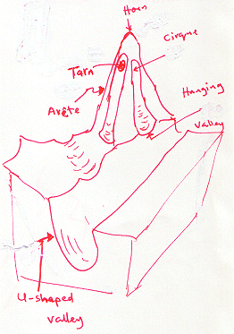
1. U-shaped valley (cross-profile) whereas V is characteristic of rivers
2. Truncated Spurs - lower part of ridges that have been (covered) into facets by glacial erosion
3. Hanging Valleys -
Rock-basin lakes - depression carved out of weaker rocks
4. Cirques - steep sided, rounded hollow carved into with mountain at the head of a glacial valley (help from weathering and erosion)
5. Horn - sharp peak that remains after cirques have cut back into a mountain on several sides
6. Arêtes - sharp ridges that separate glacially carved valley
7. Roche mountain is a small bedrock hill smoothed by the ice
on
the upper side and plucked to a rough face on the down side as the ice
pulls frequently from points and cracks
Erosional Landscapes Associated with Continental
Glaciation
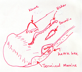
1. Drift = all material of glacial origin
2. Till - unsorted and unlayered rock debris deposited by glaciers
3. Erratic - a boulder
carried by ice usually not from the local bed rock.
Tracing the source of the boulder could help indicated glacier
direction.
Moraines - a body of till carried on or in a glacier, or left behind after glacial ice has receded.
1. Lateral moraines
2. Medial moraines occurs where glaciers meet
3. End moraines - Terminal moraine farthest along point of glacier, Recessional moraine
4. Ground moraines - fairly thin extensive layers of till
5. Drumlins - where ground moraine is reshaped into a
stream-lined
hill
6. Outwash - In wastage zone, large quantity of melt water
material
deposited by the debris - (lots of melt water) is called outwash.
This is silted and layered.
7. Esker - a long sinuous ridge of water-deposited sediment up to 10 meters high
8. Kettle - results when ice block left behind melts (depressional lakes)
9. Kames - small hills of sand and gravel dumped near edge of
ice
stratified draft
Glacier lakes and Varves
Glacier lake results from dam by glacial deposits
Varves...two layers in a glacier lake.... silt, clay represent one
year's
deposit... this can be used to date a glacial lake
Effects of Past Glaciation
Last American glacial ice melted from Canada less than 10,000 years ago.
Older glaciers are difficult to date because of less evidence due to weathering/erosion occurring during warm interglacial periods & later ice sheets & valley glaciers overriding & obliterating many of the features of earlier glaciation.
Last glacial age was at its peak about 8,000 years ago
In N. America, thousands of lakes
Indirect effect
Pluvial lakes
Lowering of sea level
Fiord - a coastal inlet that is drawn glacially curved valley
Coastal rebound
Tillite - lithified till